
Urban Redevelopment Authority (URA) is the land-use planning authority in Singapore. Singapore is a country with limited land area of 728 km², equivalent to 0.22% the size of Malaysia. Singapore has faced a low annual population growth rate, of 1.1% in 2019. This was followed by our total population, which includes citizens, permanent residents, foreign workers and students, shrinking in 2020 for the first time since 2003.
This is due to the effects of the covid pandemic, travel restrictions, labour crunch due to foreign workers returning home and lower consumer willingness to purchase goods
URA mentioned that developers sold 10,024 private residential units last year, outperforming 2019 by 112 units. Hence, this refutes the false belief that land demand is simply driven by a growing population.
However, there has been a pent-up demand by home buyers on HDB resales following the “circuit breaker” period, with 2,435 flats being sold in August 2020 and a phenomenal 3.1% change to the Resale Price Index (RPI) in the 4th quarter of 2020 from its 3rd quarter. This signals the robust land demand in Singapore for residential use.
However, this article seeks to explore a different land usage – parks. From an economist perspective, parks are deemed as public goods where society can enjoy them as third-parties without having to pay for it. This is problematic as there is no financial incentive for firms to invest heavily in a park. Hence, URA intervenes by ensuring that provision of green spaces and public goods are not compromised at the expense of commercial gain.
URA’s existing planning of Parks in Singapore
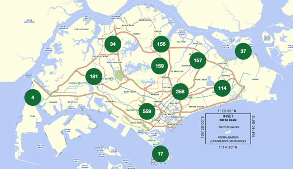
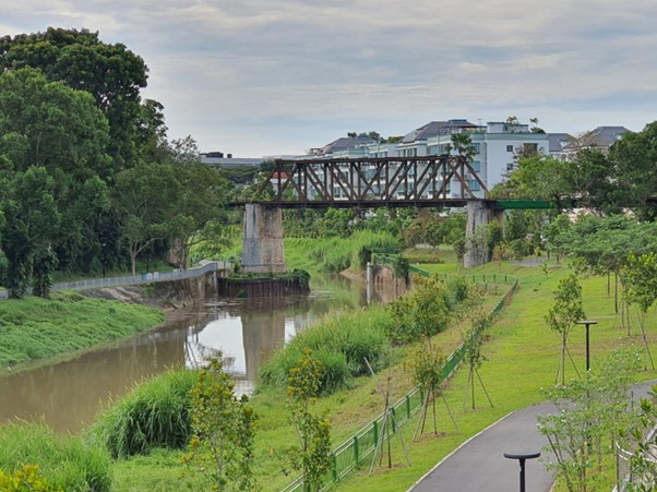
Parks represent a part of urban green spaces in Singapore. They play an important role in our city to balance the hard and soft spaces. The majority of our 453 parks overseen by National Parks (NParks) are considered manicured green spaces that are distributed throughout Singapore. It can be seen that most parks tend to be located towards the South-Eastern region of Singapore. This is partly due to our large “green lung”, central catchment nature reserve covering over 2,000 hectares of forest cover in the North Region. Also, the water catchment in the west region is a planning area that covers Tuas and Pioneer to its south, Sungei Kadut, Choa Chu Kang and Tengah to its east, Jurong West to its southeast, Lim Chu Kang to its north and the straits of Johor to its west. This area is marked for military use with designated live-firing areas and is mainly inaccessible to the public.
Role of Park Connector Networks
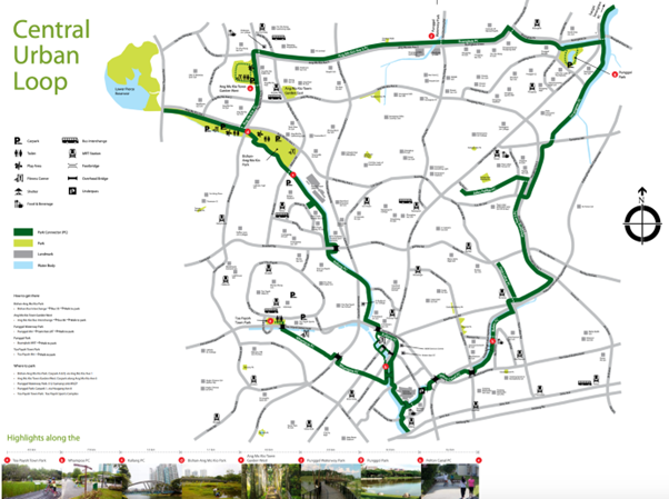
In order to understand the park distribution, we need to examine park connector networks (PCN). PCN was mooted in 1991 by The Garden City Action Committee as a network of walking/running/cycling paths that connects parks, nature sites, housing estates and green spaces in Singapore. Currently, the PCN consists of 5 Urban Loops – Central Urban Loop, Eastern Coastal Loop, Northern Explorer Loop, North Eastern Riverine Loop and Western Adventure Loop. The 26-km Central Urban Loop, for instance, encompasses iconic housing estates such as the Ang Mo Kio Ave 1 near Bishan-Ang Mo Kio park and distinctive architecture at Potong Pasir estates. This also links Toa Payoh Town Park, Punggol park and Ang Mo Kio Town Garden West.
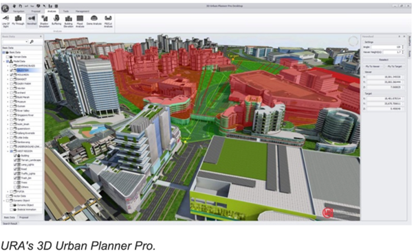
This has been expanded to the Round Island Route such as between Rower’s Bay and Gardens by the Bay to bring visitors closer to parks near bodies of water. This aligns with URA’s vision to complement green and blue options. The connectivity runs along the Rail Corridor with a total loop of 120km. In addition, the 36km Coast-to-coast Trail stretches from Jurong lake Gardens in the west, to Lornie Nature corridor near the central area and even Coney Island Park in the northeast. NParks also came up with a mobile application using Augmented Reality (AR) technology to provide visitors with a more informative learning experience through the places of interest. This is in line with URA’s vision to assess the impact of existing and future planning decisions on the urban environment, aesthetic and our city’s skyline. This technology provides an invaluable viewpoint in an immersed virtual space compared to a 3D model projected onto a screen. It allows the user to visualise large spaces like courtyards to even pedestrian paths with greater insight.
Perspective of Master Plan 2019
Over the years, few organisations have worked together to improve this park connectivity. LTA promotes cycling through its National Cycling Plan by constructing cycling paths at intra-town (short distance to MRT station) and inter-town areas (long-distance between several MRT stations). Moreover, URA plays a critical role through its Master Plan by designating the zoning land use of regions around Singapore. In the Master Plan 2019, URA plans statutory land use during a medium term of 10 to 15 years. This covers five key themes; Liveable and inclusive communities, local Hubs, Global Gateways, Rejuvenating Familiar Places, A sustainable and resilient city of the future and convenient and sustainable mobility. In its 2019 written statement, it highlights that zoning of parks are defined as areas used for the enjoyment of the general public and includes pedestrian linkages – National Park, Regional Park, Community Park, Park Connectors and Botanical gardens. It also states that additional sites for parks can be secured by the competent authority and that its precise boundaries are subject to interpretation and determination by these authorities. According to NParks in 2011, they categorised the size of parks according to its usage. For example, city and heritage parks such as the War Memorial Park does not exceed 1.4 Hectares whereas Hillside parks such as Hortpark alone commands a sizable 9 hectares.
The URA Leisure Plan in 2008 ambitiously aimed to strengthen “Singapore’s lush green experience” by tippling existing PCN to 360km and increasing the areas of greenery from 3300 to 4200 ha with more and a greater variety of parks. The PCN is expected to grow to 400km by 2030, with 13 new Active, Beautiful, Clean Programme (ABC) projects upcoming in the next 5 years to improve communal spaces to waterbodies.
LUSH Programme
We must recognise that manicured Parks in Singapore represent just a component of urban green spaces. Other areas include over 2.9million roadside trees planted by town councils and National Parks Board, Primary rainforest areas, cemeteries and community gardens. Thus,
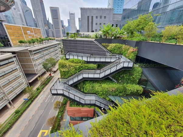
The Lush (Landscaping for Urban Space and High-Spaces) Programme which started in 2009 does not contribute to parks directly but plays a major role towards injecting greenery through architecture in city areas. It provides incentives like the Sky Terrace GFA Exemption scheme. There are over 100ha of high-rise greenery covering building exteriors islandwide with this target set to double by 2030 according to Sustainable Singapore Blueprint in 2015. This is the green space of the future where we can infuse green spaces into the built environment in a sustainable manner rather than relying on separated zoning areas such as parks.
URA’s Future planning of parks
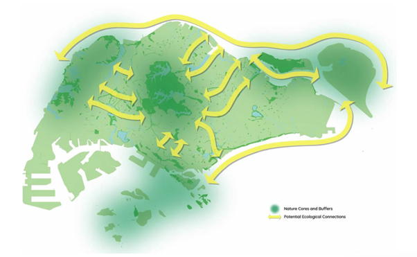
In planning with nature, URA believes that the future of nature conservation involves paying close attention to nature cores and buffers with potential ecological connections. Apart from improving connectivity between green spaces and enhancing the soft-hard space integration, we should also focus on safeguarding these biodiversity regions. As seen in the diagram above, it demonstrates the migratory patterns in the Central and Bukit Timah Nature reserve as well as the coastal connectivity areas; Sungei Buloh Wetland Reserve to Woodlands Waterfront park, Sembawang park, Pasir Ris and East Coast. Today, the effect of this transformation can be seen on the property market. According to the Ministry of Development, the waterfront land at Sembawang coastline would be freed up once the shipyard facilities are phased out. This might provide greater opportunities for coastal preservation as well as presenting a new waterfront district in Singapore’s Resale market.